MY BLOGS

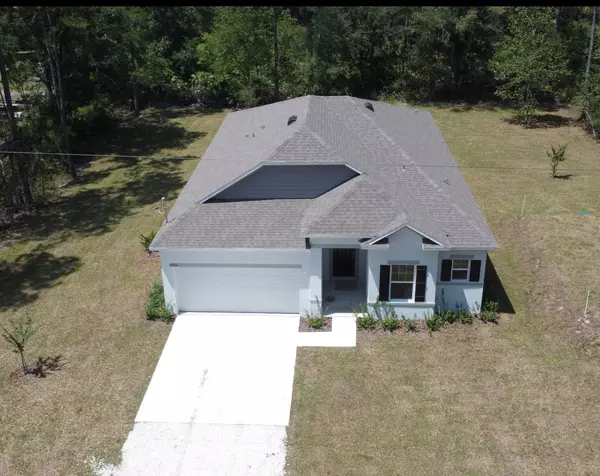
4450 Palatka Blvd, Flagler Estates, Hastings FL 32145
New Construction Flagler Estates Broker Services available for in-person and Live video showings 4450 Palatka Blvd, Flagler Estates, Hastings FL 32145 New Construction affordable home sitting on over an acre available for immediate occupancy. Desireable St. John's County. Country living, zoning allows for horses and other livestock. Close to St. Augustine, Palm Coast, Beaches, Shopping. 4 bedrooms, 2 baths, 2 car garage, 1988 sqft High ceilings Enhanced Vinyl Plank Flooring with carpet in the bedrooms Windows added to the Nook area Extra lights added to the Great Room Tiled shower walls in the Masher Shower Comfort Height toilets in all bathrooms Pre-plumbed for water softener Master Bath Master Shower Master bedroom Bedroom 2 car garage Courtasy of ADNORAM REALTY

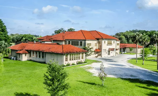
Transforming History: Hastings Library Set to Become Technical College Campus
Exciting news is brewing in St. Johns County as plans are in motion to convert the historic Hastings library into a state-of-the-art technical college campus. This ambitious project, expected to cost at least $20 million, marks a significant step forward in the revitalization of the Hastings community. Funding for the project will be sourced from a variety of avenues, including contributions from the district, a generous $10 million grant, and funds available from the American Rescue Plan. This diverse funding approach reflects a commitment to investing in the future of education and the community as a whole. Discussions surrounding the transformation of the former Hastings High School into the new First Coast Technical College campus took center stage during a recent meeting of the St. Johns County School Board. While there was initial consideration given to demolishing the nearly century-old building, it was ultimately decided that renovation would be the path forward. Architects have been diligently assessing the building to ensure that the renovation meets both the educational needs of the community and preserves the historic charm of the structure. A comprehensive plan is expected to be released later this year, offering a glimpse into the exciting future of this landmark building. The transformation of the Hastings library into a technical college campus represents more than just a renovation project—it's a symbol of progress, opportunity, and community revitalization. As the project continues to unfold, it will undoubtedly serve as a beacon of hope and inspiration for the residents of Hastings and beyond. Stay tuned for updates as we embark on this transformative journey together!

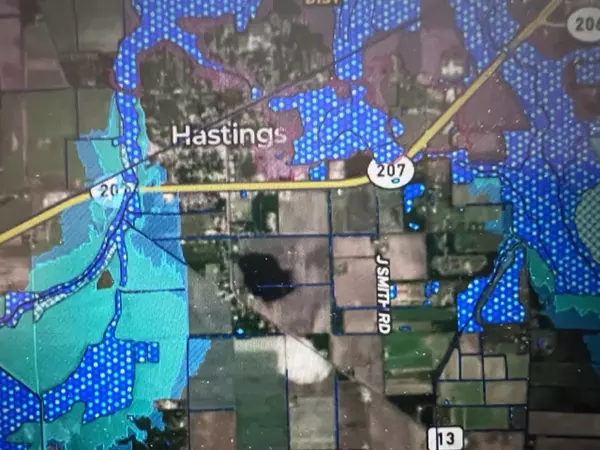
Navigating Your Land Purchase: The Importance of Mapping Tools
In the realm of real estate, buying land is a significant investment that requires careful consideration and planning. Whether you're looking to build your dream home, invest in vacant land, start a business, or invest in agricultural ventures, the importance of mapping tools cannot be overstated. These powerful tools provide invaluable insights and information that can help you make informed decisions and navigate the complexities of land acquisition with confidence. Understanding the Terrain One of the primary benefits of mapping tools is their ability to provide detailed information about the terrain of a potential land parcel. From elevation data to slope analysis, mapping tools can give you a clear picture of the topography of the land. This information is crucial for assessing factors such as drainage, flood risk, and suitability for construction or agriculture. By understanding the lay of the land, you can identify potential challenges and opportunities before making a purchase decision. Exploring Boundaries and Property Lines Mapping tools are also essential for determining property boundaries and delineating land parcels accurately. With tools like GPS technology and satellite imagery, you can precisely identify the boundaries of a property and verify its size and dimensions. This is crucial for ensuring that you are purchasing the correct parcel of land and avoiding potential boundary disputes in the future. Additionally, mapping tools can help you assess neighboring properties and understand their proximity to your own land, providing valuable context for your purchase. Assessing Environmental Factors Another key aspect of land acquisition is understanding the environmental factors that may impact the property. Mapping tools can provide valuable information about natural features such as water bodies, wetlands, and vegetation cover. This information is essential for assessing the ecological value of the land and identifying potential conservation or preservation opportunities. Additionally, mapping tools can help you evaluate environmental risks such as flood zones, erosion, and soil quality, allowing you to make informed decisions about the suitability of the land for your intended use. Planning for Development and Land Use Mapping tools play a crucial role in the planning and development process, helping you visualize and conceptualize potential projects on the land. Whether you're planning to build a home, develop a commercial property, or establish agricultural operations, mapping tools can help you design and layout your project with precision. By overlaying zoning regulations, land use restrictions, and other relevant data on top of the map, you can ensure compliance with local regulations and optimize the use of the land for your specific needs. In conclusion, mapping tools are indispensable tools for anyone involved in the process of buying land. From understanding the terrain and exploring boundaries to assessing environmental factors and planning for development, these tools provide invaluable insights that can inform and guide your decision-making process. Personally, I like using mapID and onX, but there are many other mapping programs that provide a variety of layers, including soils, FEMA flood zones, wetlands, private/government lands, etc. As valauble as these mapping tools are, please be aware they are in no way designed to replace a survey or a wetlands deliniation. Look for professional surveyors and wetlands scientists in our professional section or search the internet.
